Mission Photograph Albums - Maps-Charts #01 Page_0152
|
|
Dublin CoreTitleMission Photograph Albums - Maps-Charts #01 Page_0152
Date1910s-1920s
CreatorBoard of Missions of the Methodist Episcopal Church
SubjectMissions
Maps
RightsFor permission to use or for higher quality reproduction contact research@gcah.org
PublisherThe General Commission on Archives and History of the United Methodist Church
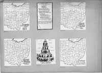
ScriptusTranscriptionH12379 Map of Ohio Counties in Strictly Rural Townships, Average Number of Person to Each Resident Minister by Counties.
H12451 Statement by Harry Hermann to join the Anti-Enlistment League. H12380 Map of Ohio Counties. Region Where Missionary Aid is Needed and Adjacent Counties Needing Missionary Aid. H12381 Map of Ohio Counties. Per Cent Increase in Value of All Farm Property from the Year 1900 to `1910 according to the United States Census Reports. H12454 Chart of the Pyramid of Capitalist System. H12382 Map of Ohio Counties. Value of Farm Property in the Year 1910. StatusStarted
Percent Completed100
Percent Needs Review0
|