Mission Photograph Albums - Maps-Charts #01 Page_0129
|
|
Dublin CoreTitleMission Photograph Albums - Maps-Charts #01 Page_0129
Date1910s-1920s
CreatorBoard of Missions of the Methodist Episcopal Church
SubjectMissions
Maps
RightsFor permission to use or for higher quality reproduction contact research@gcah.org
PublisherThe General Commission on Archives and History of the United Methodist Church
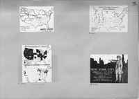
ScriptusTranscriptionH7751 Map Showing Boundary, Routes, Old Stage Roads and Mission Stations in the United States.
H7763 Map show the Frontier States Passing the Modern Test or Applied Christianity. H7764 Map Comparing the Wet and Dry States of January 1, 1893, and January 1, 1919. H7767 Ad for New York City. American's Greatest Mission Field by Fred Winslow Adams and Illustrated by Ralph E. Diffendorfer. StatusStarted
Percent Completed100
Percent Needs Review0
|